
Nanjing Yangtze River Water Emergency Rescue Base (hereinafter referred to as Nanjing Rescue Base) recently introduced a high-performance 3D side-scan sonar system. This addition infuses new technological momentum into the emergency rescue and navigation safety infrastructure for the lower Yangtze River waters, further bridging a gap in the application of high-precision underwater detection equipment within the region.
Reportedly, the core capabilities of this sonar are precisely tailored to the navigation channel characteristics and rescue requirements of the lower reaches of Yangtze River. Operating at a frequency of 450 kHz, it leverages the advantages of high-frequency signal transmission to achieve detailed capture of underwater targets. With a detection range exceeding 100 meters, it can comprehensively cover the broad channel areas of the lower reaches. The system rapidly converts detected underwater terrain and object data into high-definition 3D models, providing a clear basis for swift decision-making.
To ensure the new equipment becomes operational quickly, the Nanjing Rescue Base promptly organized an intensive one-week specialized training program. A model of combining "theoretical instruction and hands-on drills" is adopted to holistically enhance the technical staff's operational and application skills. During this period, the team systematically studied equipment principles, parameter configuration, and troubleshooting. They also conducted practical exercises simulating real-world scenarios, ensuring every operator thoroughly masters the essential aspects of the device and laying a solid foundation for its subsequent practical application.
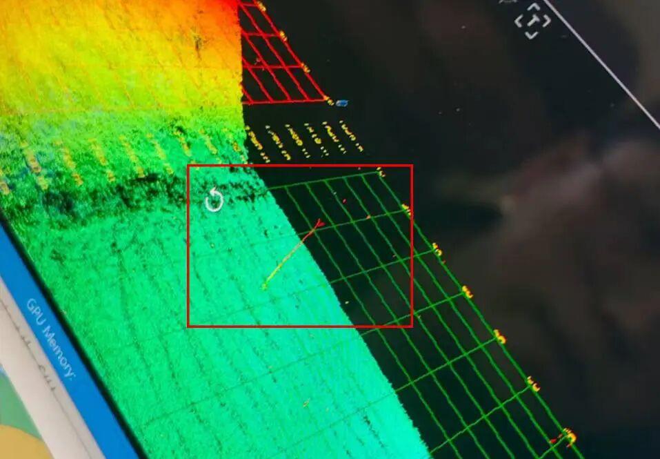
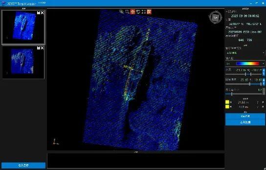
In recent operational tests, the performance advantages of this sonar were fully validated. Conducted in the busy waterways of the lower Yangtze River at a vessel speed of 10 knots, the tests involved 3D point cloud detection of known and unknown underwater targets. The equipment not only quickly identified common objects like anchor chains and sunken hulls but also accurately detected a shipwreck (designated Wreck No. 1). Data comparison confirmed the wreck's length at approximately 22 meters and width at about 4 meters. Crucially, details such as the location of hull damage and the situation of surrounding siltation were clearly rendered in the 3D model, demonstrating the system's core strengths:" rapid imaging, high precision, and accurate identification of small targets."
Upholding its mission of "Safeguarding Navigation and Assisting the River", the Nanjing Rescue Base continues to promote the deep integration of technology and emergency rescue work. The deployment of this sonar not only enables to pinpoint underwater hazards but also elevates the "search and locating" capability of emergency rescue operations to a new level.
Looking ahead, the Nanjing Rescue Base plans to further deepen the practical application of this advanced equipment. This includes optimizing detection procedures based on the specific characteristics of the lower Yangtze channel, continuously enhancing technician training and improving equipment utilization efficiency and emergency response capabilities. Through these technological enhancements, the base is committed to strengthening the safety net for shipping in the lower reaches of Yangtze River, contributing significantly to securing the safety and smooth flow of the Golden Waterway and supporting regional economic development.
Source from: China Transportation News Network